Map of the Route of the Exodus
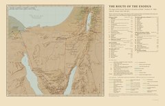
The Route of the Exodus · Exodus 12 to Numbers 33: the forty-two stages of the journey from Rameses to the plains of Moab
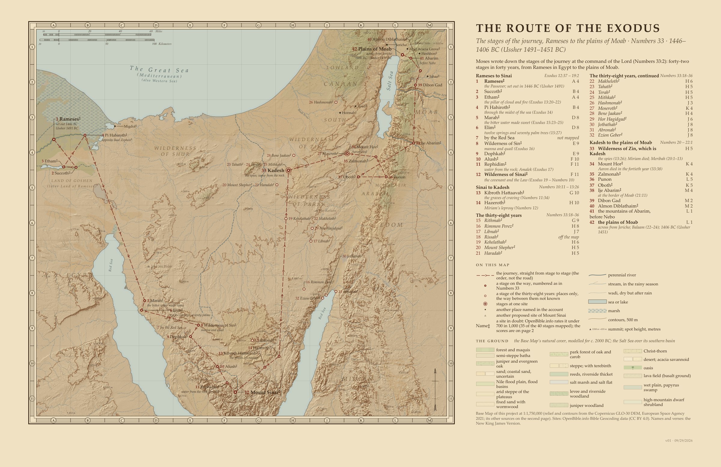
The Route of the Exodus, version 1. Sources: the New King James Version, the Copernicus GLO-30 relief, OpenStreetMap’s rivers, OpenBible.info’s places and Ussher’s Annals as a check. Click the map to enlarge.Full size
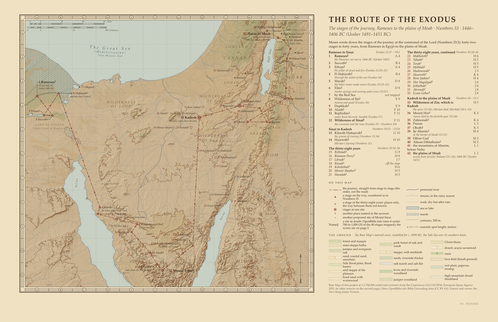
A relief map of the forty-two stages of the journey in Numbers 33, from Rameses in Egypt to the plains of Moab across from Jericho. Moses wrote the stages down at the command of the LORD (Numbers 33:2); the map joins them with straight lines in the order Scripture gives, from the crossing of the sea to Mount Sinai, by Kadesh, and around Edom.
Each site follows OpenBible.info’s first identification of the place named in the verse, with its score of confidence out of 1,000; a score under 700 is marked ‡, as disputed, and thirty-five of the forty mapped stages fall below that line. Mount Sinai is set at Jebel Musa; its other proposed sites are drawn faded. The thirty-eight years of wandering are shown as places only, most known only from this list, not joined by the route line.
The relief comes from the Copernicus GLO-30 elevation model and the towns are placed by the OpenBible.info Bible Geocoding data; where a site is uncertain, the map follows its best estimate. Names follow the New King James Version.
Map by View.Bible. Relief from the Copernicus GLO-30 elevation model (ESA, 2021); rivers and streams from OpenStreetMap (© OpenStreetMap contributors, ODbL); site positions from OpenBible.info (CC BY 4.0).
When
1446–1406 BC: 1 Kings 6:1 puts the Exodus 480 years before Solomon’s fourth year, 966 BC, the Kings chart’s reckoning; Ussher’s reckoning gives 1491–1451 BC. Both are reckonings from the years and ages Scripture gives, not statements of Scripture (how the years are counted).
See it on the timeline →Downloads
The stages of the journey, one by one (42)
The forty-two stages of Numbers 33:1–49, in order; ‡ marks a site OpenBible.info scores under 700, as disputed. The seventh stage, by the Red Sea, names no place and is not mapped.
| No. | Name | Numbers 33 | What happened | Site | Score |
|---|---|---|---|---|---|
| 1 | Rameses | 33:3, 5 | set out the day after the Passover (Exodus 12:37) | Qantir | 509‡ |
| 2 | Succoth | 33:5–6 | the first camp (Exodus 12:37; 13:20) | Tell el Maskhuta | 206‡ |
| 3 | Etham | 33:6–7 | at the edge of the wilderness; the pillar of cloud and fire (Exodus 13:20–22) | Tell er Retaba | 72‡ |
| 4 | Pi Hahiroth | 33:7–8 | east of Baal Zephon, near Migdol; through the midst of the sea (Exodus 14) | Tell Defenneh | 75‡ |
| 5 | Marah | 33:8–9 | three days in the Wilderness of Etham; the bitter water made sweet (Exodus 15:22–25) | Ain Hawarah | 384‡ |
| 6 | Elim | 33:9–10 | twelve springs of water and seventy palm trees (Exodus 15:27) | Wadi Gharandal | 533‡ |
| 7 | by the Red Sea | 33:10–11 | the place not given | no place named | not mapped |
| 8 | Wilderness of Sin | 33:11–12 | manna and quail (Exodus 16) | Debbet er Ramleh | 311‡ |
| 9 | Dophkah | 33:12–13 | Serabit el Khadim | 441‡ | |
| 10 | Alush | 33:13–14 | Wadi el Esh | 302‡ | |
| 11 | Rephidim | 33:14–15 | no water: water from the rock; Amalek (Exodus 17) | Wadi Rufaiyil | 379‡ |
| 12 | Wilderness of Sinai | 33:15–16 | the covenant and the Law (Exodus 19 – Numbers 10) | Jebel Musa | 465‡ |
| 13 | Kibroth Hattaavah | 33:16–17 | the graves of craving (Numbers 11:34) | Erweis el Ebeirig | 405‡ |
| 14 | Hazeroth | 33:17–18 | Miriam struck with leprosy (Numbers 11:35 – 12:16) | Ain el Khadra | 481‡ |
| 15 | Rithmah | 33:18–19 | Wadi Ratamah | 235‡ | |
| 16 | Rimmon Perez | 33:19–20 | Naqb al Biyar | 144‡ | |
| 17 | Libnah | 33:20–21 | Wadi el Beidha | 129‡ | |
| 18 | Rissah | 33:21–22 | Sharma | 469‡ | |
| 19 | Kehelathah | 33:22–23 | Kuntillet Ajrud | 80‡ | |
| 20 | Mount Shepher | 33:23–24 | Wadi Lussan | 172‡ | |
| 21 | Haradah | 33:24–25 | Wadi Lussan | 176‡ | |
| 22 | Makheloth | 33:25–26 | Kuntillet Ajrud | 145‡ | |
| 23 | Tahath | 33:26–27 | Wadi Umm Hashim | 91‡ | |
| 24 | Terah | 33:27–28 | Wadi Umm Hashim | 126‡ | |
| 25 | Mithkah | 33:28–29 | Wadi Umm Hashim | 126‡ | |
| 26 | Hashmonah | 33:29–30 | Tell es Saqati | 71‡ | |
| 27 | Moseroth | 33:30–31 | Moserah (Deuteronomy 10:6) | Har Zin | 192‡ |
| 28 | Bene Jaakan | 33:31–32 | Birein | 385‡ | |
| 29 | Hor Hagidgad | 33:32–33 | Wadi Khadakhid | 317‡ | |
| 30 | Jotbathah | 33:33–34 | a land of rivers of water (Deuteronomy 10:7) | Taba | 352‡ |
| 31 | Abronah | 33:34–35 | Aqaba | 141‡ | |
| 32 | Ezion Geber | 33:35–36 | Jezirat Faraun | 360‡ | |
| 33 | Wilderness of Zin, which is Kadesh | 33:36–37 | the spies returned (Numbers 13:26); Miriam died; water from the rock (Numbers 20:1–13) | Ain el Qudeirat | 864 |
| 34 | Mount Hor | 33:37–41 | Aaron died there, aged 123, in the fortieth year (33:38–39) | Har Zin | 336‡ |
| 35 | Zalmonah | 33:41–42 | from Mount Hor around Edom; the bronze serpent, before Oboth (Numbers 21:4–10) | Wadi es Salmaneh | 329‡ |
| 36 | Punon | 33:42–43 | Khirbet Faynan | 755 | |
| 37 | Oboth | 33:43–44 | camped after the bronze serpent (Numbers 21:10) | Ein Weibeh | 361‡ |
| 38 | Ije Abarim | 33:44–45 | at the border of Moab (Numbers 21:11) | Medeineh | 403‡ |
| 39 | Dibon Gad | 33:45–46 | Tall Dhiban | 1000 | |
| 40 | Almon Diblathaim | 33:46–47 | Duleilat esh Sharqiyeh | 182‡ | |
| 41 | the mountains of Abarim, before Nebo | 33:47–48 | the Abarim range (representative point) | ||
| 42 | the plains of Moab | 33:48–49 | by the Jordan across from Jericho, from Beth Jesimoth to the Abel Acacia Grove; Balaam (Numbers 22–24) | Tell Azeimeh | 799 |
Mount Sinai
Mount Sinai is set at Jebel Musa, OpenBible.info’s first identification for the place (a score of 465), with the Wilderness of Sinai, the twelfth stage. Its other proposed sites are drawn faded on the map: Har Karkom (103), Jebel Sin Bishar (89) and Jebel Serbal (54).
The stages not mapped
The seventh stage, by the Red Sea (Numbers 33:10–11), names no place and is not mapped. Rissah, the eighteenth stage, has only one proposed site, Sharma, which lies in Arabia, south of this map, and so is not shown either.
The thirty-eight years
The stages of the thirty-eight years (Numbers 33:18–36, Rithmah to Ezion Geber) are shown as places only, not joined by the route line: most are known only from this list, and OpenBible.info puts several at one site (Kehelathah and Makheloth; Mount Shepher and Haradah; Tahath, Terah and Mithkah, beside Kadesh; and Moseroth with Mount Hor).
How sites are marked
Each site is OpenBible.info’s first identification of the place named in the verse, followed to the modern site; the score is its confidence out of 1,000. A site scored under 700 is marked ‡, as disputed: thirty-five of the forty mapped stages fall below that line.
The crossing of the sea
Exodus 14:2 sets the camp before Pi Hahiroth, between Migdol and the sea, opposite Baal Zephon; OpenBible.info puts Pi Hahiroth and Baal Zephon both at Tell Defenneh. Where the sea was crossed is not known, and the line from Pi Hahiroth to Marah marks no crossing place.
Around Edom
Numbers 20:14–21 and 21:4 say that Edom refused Israel the way through its land, so the journey went around it. OpenBible.info’s sites for Zalmonah, Punon and Oboth lie in and beside the Arabah, so the line on the map crosses it twice; the sites set that course, not the text.
Other places on the map
Ten more places appear on the map besides the forty-two stages. Migdol and Baal Zephon (33:7; Exodus 14:2) lie by the crossing of the sea. Arad (33:40; Numbers 21:1–3) and Hormah (Numbers 14:45; 21:3), and Heshbon (Numbers 21:25–30) and Jahaz (Numbers 21:23), lie near the route east of the Jordan. Jericho (33:48, 50) and the Abel Acacia Grove (33:49) lie across the Jordan from the plains of Moab, and Mount Nebo (Deuteronomy 32:49; 34:1–5) is where Moses viewed the land.
The Salt Sea
The Salt Sea is drawn over its southern basin, as in the days of Moses and Joshua: all the ground lower than 385 m below sea level. The base map’s level for about 2000 BC, 415 m below sea level, is not used here.
Sources
New King James Version
Names, spellings, ages and short quotations.
Scripture taken from the New King James Version®. Copyright © 1982 by Thomas Nelson. Used by permission. All rights reserved.
Copernicus GLO-30 digital elevation model
The shaded relief and contours; the streams traced on the GLO-90 model.
© DLR e.V. 2010–2014 and © Airbus Defence and Space GmbH 2014–2018 provided under COPERNICUS by the European Union and ESA; all rights reserved.
Copernicus DEM, https://spacedata.copernicus.eu/collections/copernicus-digital-elevation-model
OpenStreetMap
Today’s rivers, streams and works, as the sheet’s sources say.
© OpenStreetMap contributors. The data is available under the Open Database License (https://www.openstreetmap.org/copyright).
OpenBible.info Bible Geocoding data
The positions of the towns.
Site positions adapted from the Bible Geocoding data at OpenBible.info (https://www.openbible.info/geo/), licensed under CC BY 4.0 (https://creativecommons.org/licenses/by/4.0/). Uncertain identifications follow its best estimate.
James Ussher, Annals of the World (1650–1654)
A check on the reckoning of the years. Public domain.
The waters
The relief, rivers, streams and the Salt Sea’s ancient level.
Relief and contours: Copernicus GLO-30 digital elevation model (European Space Agency, 2021), produced using Copernicus WorldDEM™-30 © DLR e.V. 2010–2014 and © Airbus Defence and Space GmbH 2014–2018 provided under COPERNICUS by the European Union and ESA; all rights reserved. Streams traced on the GLO-90 model. Today’s canals, drains, dams, dikes, embankments, reservoirs and salt and fish ponds taken off the heights the contours are traced on with OpenStreetMap (© OpenStreetMap contributors, ODbL). River courses of c. 2000 BC as in the base map’s data, guided by OpenStreetMap; the smaller perennial streams from OpenStreetMap; © OpenStreetMap contributors, ODbL. Wadis are the traced streams where the ground gets less than 250 mm of rain a year. The Salt Sea c. 2000 BC at 415 m below sea level: Migowski et al. 2006; Kagan et al. 2015; Frumkin 2009.
The natural cover
The ground cover shown on the map, modelled for about 2000 BC.
Natural cover: the potential natural vegetation under today’s rainfall (1981–2020), taken as the setting c. 2000 BC, when the land stood near a woodland high point with a drought setting in (Langgut et al. 2015; Kaniewski et al. 2018; Palmisano et al. 2019). Modelled by the rules of Danin 1992 (Flora and vegetation of Israel and adjacent areas, Bocconea 3) on rainfall, height and rock, checked against Danin’s map, Soto-Berelov et al. 2012, Al-Eisawi 1985 (Jordan) and Abi-Saleh and Safi 1988 (Lebanon). Rainfall: the CHELSA V2.1 climatology 1981–2010 (Karger et al., CC0) corrected to rain gauges (GHCN, NOAA; national normals) for the rain shadow of the ridges.
The ground
The rock and soil beneath the relief.
Ground: Geological Map of Israel 1:200,000 and 1:50,000 (Geological Survey of Israel); Bender’s Geologic Map of Jordan (USGS Professional Paper 560-I), digitised by M. Kempf 2023 (CC BY 4.0); USGS geo2bg (Open-File Report 97-470B). Coastal dunes beyond 3 km of the sea are mostly later than 2000 BC (Roskin et al. 2015) and are shown as uncertain.
Egypt’s waters and cover
The Delta’s lakes, shores and branches, and Egypt’s natural cover.
The Faiyum lake c. 2000 BC at its low stand, 20 m below sea level (Marks et al. 2018). The Bitter Lakes a salt flat (contested), Lake Timsah a marsh and a seasonal lake in the western Wadi Tumilat (Moshier and Hoffmeier 2015). The coast south-west of Tell el-Farama, before the Tineh plain formed (Stanley et al. 2008; Goodfriend and Stanley 1999); the Canopic promontory as marsh and lagoon (Flaux et al. 2017). The Ahramat Branch digitised from Ghoneim et al. 2024 (CC BY 4.0). Natural cover in Egypt: the Nile valley, Delta and Faiyum follow flood, water and ground, not rain (Butzer 1976; Marks et al. 2018). Sinai follows the vegetation types of Boulos 2008, its northern sands fixed (Karnieli and Tsoar 1995); the rain rules of Danin 1992 hold there and on the coast west of the Delta. Modern rainfall is kept: near-modern aridity had come by c. 2500 BC (Butzer 1976). Rainfall: CHELSA V2.1 (Karger et al., CC0) corrected to rain gauges (WMO normals and GHCN, NOAA; El-Bagouri et al. 1995).
Every source the site uses: Sources.
How to cite
From View.Bible, The Route of the Exodus (Exodus 12 – Numbers 33), version 1, https://view.bible/exodus-route-map/, CC BY 4.0.