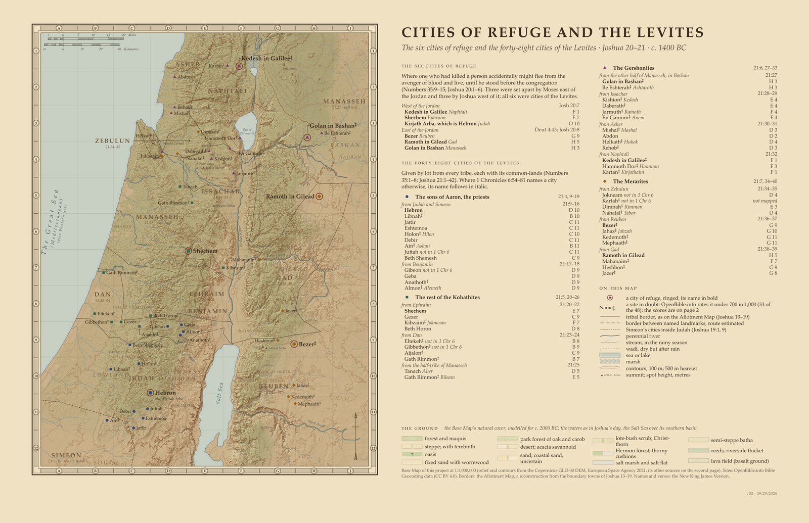
Cities of Refuge Map: the Six Cities and 48 Levitical Cities
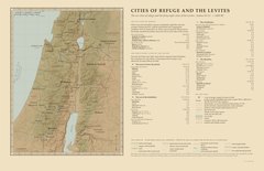
Cities of Refuge and the Levites · Joshua 20–21: the six cities of refuge, and the forty-eight cities of the Levites by family and tribe
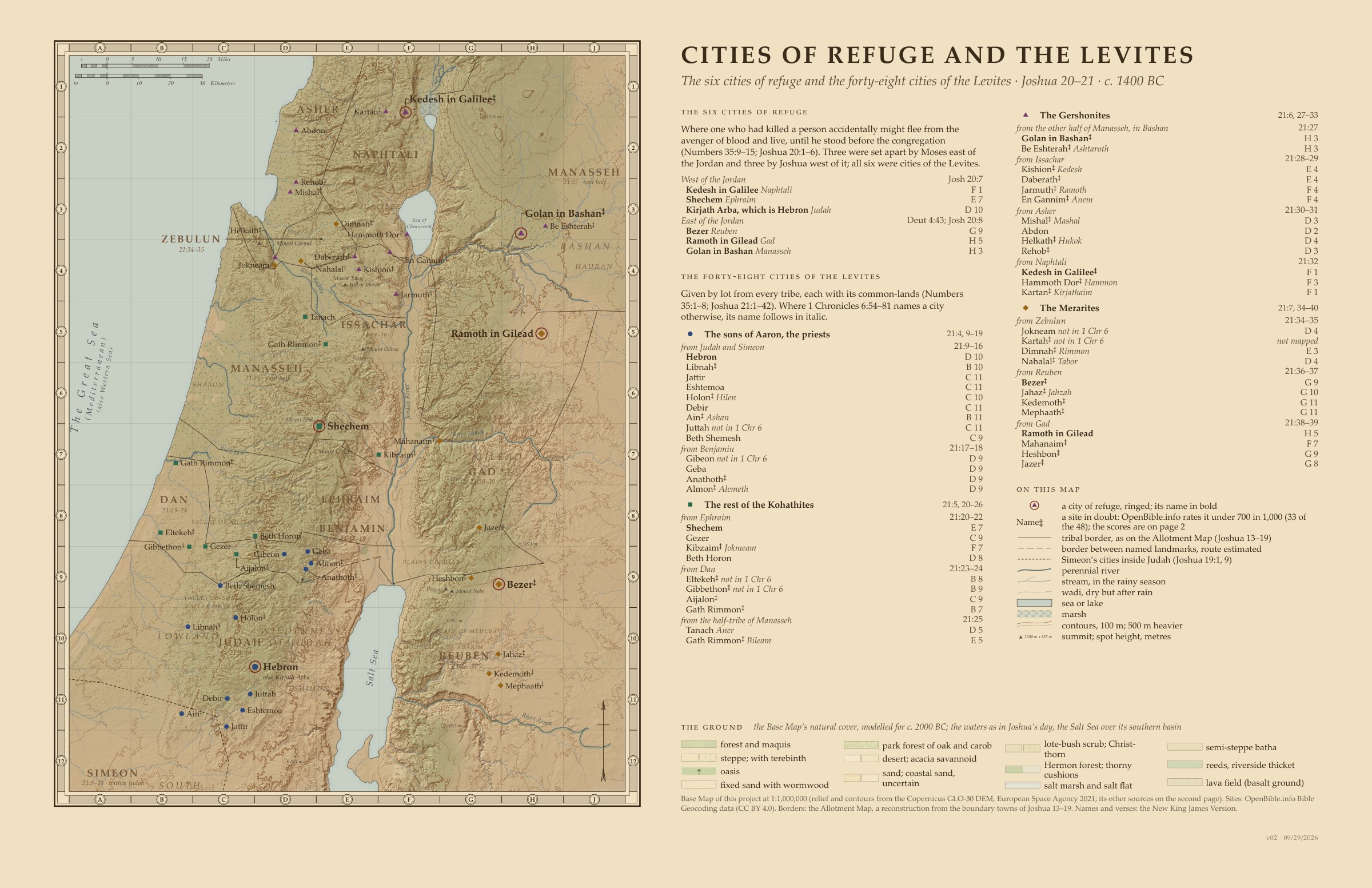
Cities of Refuge and the Levites, version 2. Sources: the New King James Version, the Copernicus GLO-30 relief, OpenStreetMap’s rivers and OpenBible.info’s places. Click the map to enlarge.Full size
A map of the forty-eight cities the Levites received by lot among the tribes, Joshua 21, and the six cities of refuge among them. Each city carries its family and tribe and its verses; where 1 Chronicles 6:54–81 names a city otherwise, its name follows in italic.
The forty-eight fall to four Levitical families, each marked on the map by its own shape and colour: thirteen cities to the sons of Aaron the priests, ten to the rest of Kohath, thirteen to Gershon and twelve to Merari. A site OpenBible.info rates under 700 in 1,000 is marked ‡; thirty-three of the forty-eight are so marked.
The relief and contours come from the Copernicus GLO-30 elevation model, the site positions from the OpenBible.info Bible Geocoding data, and the tribal borders from View.Bible’s Allotment Map, a reconstruction from the boundary towns of Joshua 13–19. Names and verses follow the New King James Version.
Map by View.Bible. Relief from the Copernicus GLO-30 elevation model (ESA, 2021); rivers and streams from OpenStreetMap (© OpenStreetMap contributors, ODbL); site positions from OpenBible.info (CC BY 4.0).
When
1451–1444 BC, as Archbishop Ussher reckoned the years: a reckoning from the ages Scripture gives, not a statement of Scripture (how the years are counted).
See it on the timeline →Downloads
The forty-eight cities of the Levites (48)
In Joshua 21’s order, family by family. ‡ after a score marks a site OpenBible.info rates under 700 in 1,000 (33 of the 48). Where 1 Chronicles 6 names a city otherwise, its name and verse follow in the Verses column; Kartah, no. 38, is not mapped.
| No. | Name | Tribe | Family | Refuge | Verses | Site | Score |
|---|---|---|---|---|---|---|---|
| 1 | Hebron | Judah and Simeon | Aaron | Joshua 20:7; 21:13 | Joshua 21:11, 13; 1 Chronicles 6:55, 57 | Tel Rumeida | 1000 |
| 2 | Libnah | Judah and Simeon | Aaron | Joshua 21:13; 1 Chronicles 6:57 | Tell Bornat | 381‡ | |
| 3 | Jattir | Judah and Simeon | Aaron | Joshua 21:14; 1 Chronicles 6:57 | Khirbet Attir | 1000 | |
| 4 | Eshtemoa | Judah and Simeon | Aaron | Joshua 21:14; 1 Chronicles 6:57 | As Samu | 722 | |
| 5 | Holon | Judah and Simeon | Aaron | Joshua 21:15; 1 Chronicles 6:58 (called Hilen) | Khirbet Alin | 153‡ | |
| 6 | Debir | Judah and Simeon | Aaron | Joshua 21:15; 1 Chronicles 6:58 | Khirbet Rabud | 775 | |
| 7 | Ain | Judah and Simeon | Aaron | Joshua 21:16; 1 Chronicles 6:59 (called Ashan, placed at Khirbet Asan, 442) | Tel Halif | 46‡ | |
| 8 | Juttah | Judah and Simeon | Aaron | Joshua 21:16; not in 1 Chronicles 6 | Yatta | 771 | |
| 9 | Beth Shemesh | Judah and Simeon | Aaron | Joshua 21:16; 1 Chronicles 6:59 | Tel Bet Shemesh | 864 | |
| 10 | Gibeon | Benjamin | Aaron | Joshua 21:17; not in 1 Chronicles 6 | El Jib | 912 | |
| 11 | Geba | Benjamin | Aaron | Joshua 21:17; 1 Chronicles 6:60 | Jaba | 740 | |
| 12 | Anathoth | Benjamin | Aaron | Joshua 21:18; 1 Chronicles 6:60 | Ras el Kharruba | 420‡ | |
| 13 | Almon | Benjamin | Aaron | Joshua 21:18; 1 Chronicles 6:60 (called Alemeth) | Khirbet Almit | 657‡ | |
| 14 | Shechem | Ephraim | Kohath | Joshua 20:7; 21:21 | Joshua 21:21; 1 Chronicles 6:67 | Tell Balatah | 1000 |
| 15 | Gezer | Ephraim | Kohath | Joshua 21:21; 1 Chronicles 6:67 | Tel Gezer | 942 | |
| 16 | Kibzaim | Ephraim | Kohath | Joshua 21:22; 1 Chronicles 6:68 (called Jokmeam) | Tel al Mazar | 123‡ | |
| 17 | Beth Horon | Ephraim | Kohath | Joshua 21:22; 1 Chronicles 6:68 | Beit Ur al Tahta | 1000 | |
| 18 | Eltekeh | Dan | Kohath | Joshua 21:23; not in 1 Chronicles 6 | Tel Shalaf | 414‡ | |
| 19 | Gibbethon | Dan | Kohath | Joshua 21:23; not in 1 Chronicles 6 | Tell Melat | 530‡ | |
| 20 | Aijalon | Dan | Kohath | Joshua 21:24; 1 Chronicles 6:69 | Yalo | 665‡ | |
| 21 | Gath Rimmon | Dan | Kohath | Joshua 21:24; 1 Chronicles 6:69 | Tel Gerisa | 338‡ | |
| 22 | Tanach | Half Manasseh (west) | Kohath | Joshua 21:25; 1 Chronicles 6:70 (called Aner) | Tell Ta’anakh | 1000 | |
| 23 | Gath Rimmon | Half Manasseh (west) | Kohath | Joshua 21:25; 1 Chronicles 6:70 (called Bileam) | Khirbet Belameh | 365‡ | |
| 24 | Golan in Bashan | Half Manasseh in Bashan | Gershon | Deuteronomy 4:43; Joshua 20:8; 21:27 | Joshua 21:27; 1 Chronicles 6:71 | Saham al Jawlan | 680‡ |
| 25 | Be Eshterah | Half Manasseh in Bashan | Gershon | Joshua 21:27; 1 Chronicles 6:71 (called Ashtaroth) | Tell Ashtara | 602‡ | |
| 26 | Kishion | Issachar | Gershon | Joshua 21:28; 1 Chronicles 6:72 (called Kedesh) | Tell Qisyon | 447‡ | |
| 27 | Daberath | Issachar | Gershon | Joshua 21:28; 1 Chronicles 6:72 | Horvat Devora | 673‡ | |
| 28 | Jarmuth | Issachar | Gershon | Joshua 21:29; 1 Chronicles 6:73 (called Ramoth) | Kokab el Hawa | 285‡ | |
| 29 | En Gannim | Issachar | Gershon | Joshua 21:29; 1 Chronicles 6:73 (called Anem) | Khirbet Beit Jann | 167‡ | |
| 30 | Mishal | Asher | Gershon | Joshua 21:30; 1 Chronicles 6:74 (called Mashal) | Tell Keisan | 466‡ | |
| 31 | Abdon | Asher | Gershon | Joshua 21:30; 1 Chronicles 6:74 | Tel Avdon | 826 | |
| 32 | Helkath | Asher | Gershon | Joshua 21:31; 1 Chronicles 6:75 (called Hukok, placed at Tel Regev, 201) | Tel Qashish | 377‡ | |
| 33 | Rehob | Asher | Gershon | Joshua 21:31; 1 Chronicles 6:75 | Tell Bir el Gharbi | 428‡ | |
| 34 | Kedesh in Galilee | Naphtali | Gershon | Joshua 20:7; 21:32 | Joshua 21:32; 1 Chronicles 6:76 | Tel Kedesh | 599‡ |
| 35 | Hammoth Dor | Naphtali | Gershon | Joshua 21:32; 1 Chronicles 6:76 (called Hammon) | Hamat Tiberias | 483‡ | |
| 36 | Kartan | Naphtali | Gershon | Joshua 21:32; 1 Chronicles 6:76 (called Kirjathaim) | Khirbet el Qureiyeh | 397‡ | |
| 37 | Jokneam | Zebulun | Merari | Joshua 21:34; not in 1 Chronicles 6 | Tel Yokneam | 1000 | |
| 38 | Kartah | Zebulun | Merari | Joshua 21:34; not in 1 Chronicles 6 | Khirbet el Qureiyeh, not mapped (Kartan’s site, in Naphtali) | 104‡ | |
| 39 | Dimnah | Zebulun | Merari | Joshua 21:35; 1 Chronicles 6:77 (called Rimmon) | Rumana | 442‡ | |
| 40 | Nahalal | Zebulun | Merari | Joshua 21:35; 1 Chronicles 6:77 (called Tabor, placed at Iksal, 232) | Horbat Sefan | 226‡ | |
| 41 | Bezer | Reuben | Merari | Deuteronomy 4:43; Joshua 20:8 | Joshua 21:36; 1 Chronicles 6:78 (called Bezer in the wilderness) | Umm el Amad | 442‡ |
| 42 | Jahaz | Reuben | Merari | Joshua 21:36; 1 Chronicles 6:78 (called Jahzah) | Khirbet el Medeiyineh | 444‡ | |
| 43 | Kedemoth | Reuben | Merari | Joshua 21:37; 1 Chronicles 6:79 | Aleiyan | 251‡ | |
| 44 | Mephaath | Reuben | Merari | Joshua 21:37; 1 Chronicles 6:79 | Umm ar Rasas | 465‡ | |
| 45 | Ramoth in Gilead | Gad | Merari | Deuteronomy 4:43; Joshua 20:8; 21:38 | Joshua 21:38; 1 Chronicles 6:80 | Tall er Rumeith | 808 |
| 46 | Mahanaim | Gad | Merari | Joshua 21:38; 1 Chronicles 6:80 | Tell edh Dhahab el Gharbi | 654‡ | |
| 47 | Heshbon | Gad | Merari | Joshua 21:39; 1 Chronicles 6:81 | Tell Hesban | 433‡ | |
| 48 | Jazer | Gad | Merari | Joshua 21:39; 1 Chronicles 6:81 | Khirbet Sara | 281‡ |
The six cities of refuge (Joshua 20:7–8)
West of the Jordan: Kedesh in Galilee (Naphtali), Shechem (Ephraim), Kirjath Arba, that is Hebron (Judah). East of the Jordan: Bezer (Reuben), Ramoth in Gilead (Gad), Golan in Bashan (Manasseh). Anyone who killed a person by accident could flee there from the avenger of blood and live, until he stood before the congregation (Numbers 35:9–15; Joshua 20:1–9).
The Levites’ four families
Thirteen cities to the sons of Aaron the priests, from Judah, Simeon and Benjamin; ten to the rest of Kohath, from Ephraim, Dan and the half-tribe of Manasseh; thirteen to Gershon, from the other half of Manasseh in Bashan, Issachar, Asher and Naphtali; twelve to Merari, from Zebulun, Reuben and Gad (Joshua 21:4–8).
Kartah, not mapped
OpenBible.info’s only proposed site for Kartah (Joshua 21:34) is Kartan’s, in Naphtali, though Kartah was a city of Zebulun. Rather than place it at a site that is not its own, the map leaves it off: forty-seven of the forty-eight cities are shown.
Contested sites
A raised ‡ after a name marks a site OpenBible.info rates under 700 in 1,000: thirty-three of the forty-eight cities. Every site’s score is on page 2 of the PDF.
Joshua 21:36–37 and the Masoretic Text
Joshua 21:36–37, naming Bezer, Jahaz, Kedemoth and Mephaath, are not in the Masoretic Text; the New King James Version keeps them with the Septuagint and the Vulgate, as its note there says (compare 1 Chronicles 6:78–79).
Sources
New King James Version
Names, spellings, ages and short quotations.
Scripture taken from the New King James Version®. Copyright © 1982 by Thomas Nelson. Used by permission. All rights reserved.
Copernicus GLO-30 digital elevation model
The shaded relief and contours; the streams traced on the GLO-90 model.
© DLR e.V. 2010–2014 and © Airbus Defence and Space GmbH 2014–2018 provided under COPERNICUS by the European Union and ESA; all rights reserved.
Copernicus DEM, https://spacedata.copernicus.eu/collections/copernicus-digital-elevation-model
OpenStreetMap
Today’s rivers, streams and works, as the sheet’s sources say.
© OpenStreetMap contributors. The data is available under the Open Database License (https://www.openstreetmap.org/copyright).
OpenBible.info Bible Geocoding data
The positions of the towns.
Site positions adapted from the Bible Geocoding data at OpenBible.info (https://www.openbible.info/geo/), licensed under CC BY 4.0 (https://creativecommons.org/licenses/by/4.0/). Uncertain identifications follow its best estimate.
The waters
The river courses and the Salt Sea as in Joshua’s day.
River courses of c. 2000 BC as in the base map’s data, guided by OpenStreetMap; the smaller perennial streams from OpenStreetMap; © OpenStreetMap contributors, ODbL. Wadis are the traced streams where the ground gets less than 250 mm of rain a year. The Salt Sea c. 2000 BC at 415 m below sea level: Migowski et al. 2006; Kagan et al. 2015; Frumkin 2009. Lake Huleh and its marsh restored after the surveys made before the drainage of 1951–58.
The natural cover
The vegetation shown on the ground, modelled for Joshua’s day.
Natural cover: the potential natural vegetation under today’s rainfall (1981–2020), taken as the setting c. 2000 BC, when the land stood near a woodland high point with a drought setting in (Langgut et al. 2015; Kaniewski et al. 2018; Palmisano et al. 2019). Modelled by the rules of Danin 1992 (Flora and vegetation of Israel and adjacent areas, Bocconea 3) on rainfall, height and rock, checked against Danin’s map, Soto-Berelov et al. 2012, Al-Eisawi 1985 (Jordan) and Abi-Saleh and Safi 1988 (Lebanon). In southern Syria, where no vegetation map was found, the zones are extrapolated. Rainfall: the CHELSA V2.1 climatology 1981–2010 (Karger et al., CC0) corrected to rain gauges (GHCN, NOAA; national normals) for the rain shadow of the ridges.
The ground
The rock and soil beneath the relief.
Ground: Geological Map of Israel 1:200,000 and 1:50,000 (Geological Survey of Israel); Bender’s Geologic Map of Jordan (USGS Professional Paper 560-I), digitised by M. Kempf 2023 (CC BY 4.0); USGS geo2bg (Open-File Report 97-470B). Coastal dunes beyond 3 km of the sea are mostly later than 2000 BC (Roskin et al. 2015) and are shown as uncertain.
Every source the site uses: Sources.
How to cite
From View.Bible, Cities of Refuge and the Levites (Joshua 20–21), version 2, https://view.bible/cities-of-refuge-map/, CC BY 4.0.